

Why the forecast on your weather app changes so often
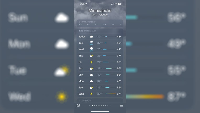
A screengrab of the iPhone weather app on Monday, April 3, shows a high of 87 degrees in the forecast for next Wednesday. (FOX 9)
MINNEAPOLIS (FOX 9) - You don't have to be a meteorologist to know the forecast changes quickly.
There are many reasons for this, but the basic principle is that the atmosphere is constantly in flux. As it changes, new data is ingested into computer models which can lead to different results moving forward. Then meteorologists adjust their forecast accordingly. That's what's involved when trying to predict the future. But over the last couple of days, the forecast seemingly went from winter to summer.
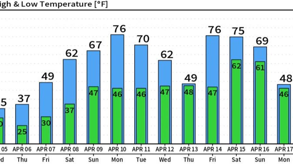
About 85% of U.S. adults use a smartphone on a daily basis and all of those phones come with a weather app ... and many choose to download more depending on their preferences. Therefore, many Minnesotans may have noticed on Monday and Tuesday of this week the second half of your 7-, 10-, or 14-day forecast on your app of choice drastically changed. Suddenly upper 80s were randomly appearing toward the middle of next week. But if you looked a few hours later, temperatures changed drastically again ... falling by some 20 degrees. A few hours later, they went back up ... and it's been this endless cycle of up and down since.
So what's the deal?
Weather apps are almost entirely automated. They have to be because most use your GPS location to display the current conditions and then a forecast for the days and weeks ahead. They have to be automated because it would take an almost unlimited number of humans to be able to develop a forecast for nearly every GPS location in the United States, let alone the world. This is great if you want to know some basic weather info for your area, but there are certainly some downsides to automation that aren't widely known.
DOWNLOAD THE FOX 9 WEATHER APP
Because the app is automated, the forecast comes straight from a computer model without any human interaction. In many cases, it comes from the GFS (Global Forecast System) model, which is considered the standard U.S. global model produced by the U.S. government. It's called a global model because it ingests data and creates a forecast for the entire globe. There are other computer models that encompass just North America, Europe, or other locations. This is the main reason why the GFS is often used because then the apps forecast can be used by the downloader anywhere in the world.
RELATED: Apple working to repair Weather app outage
The downside to using a forecast direct from just a single computer model is that it can often lead to wild swings in temperature that meteorologists usually adjust for when forecasting. Many watched this unfold through the first half of this week as the GFS was adjusting to a significant pattern change here in Minnesota. This adjustment often comes with wild swings in individual model run, but will calm down as the day gets closer.
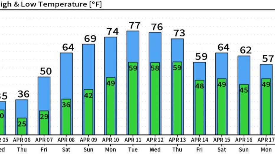
If you missed it, here's an example of what you may have seen. The following images are from four consecutive runs of the GFS model late Monday and into Tuesday. This computer model constantly ingests data and then will run its algorithm to get a forecast for every location on Earth every 6 hours. So it produces a forecast four times a day for the upcoming 10 days.
Here's the direct model data from Monday afternoon through Tuesday morning:
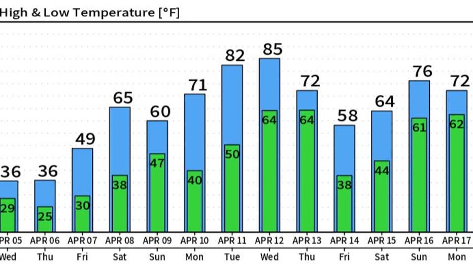
Model 1
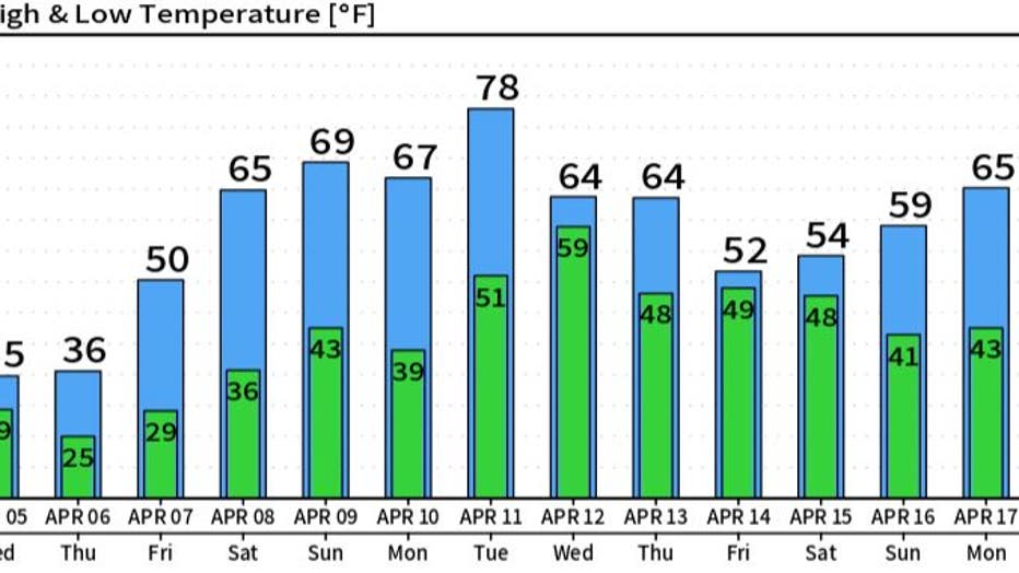
Model 2
Model 3
Model 4
Clearly, the temperatures listed in each release 6 hours apart are drastically different. Meteorologists are taught all of this in school and we see trends like this daily, but the "average Joe or Jane" would not know this and just adds more fuel to the fire that "meteorologists can't get it right." This is just the reality when using a computer model because it is asked to come up with one solution for a set of data every time it runs.
So how can you make this information useful?
Well, in those same computer model forecasts, notice the first couple of days in the forecast don't change much. This is because those days are in the near term when fewer things can happen and the overall pattern is widely known leading to more certainty and a more consistent forecast. But the further you get in time, the more variables can change the forecast, which could lead to drastically different results.
A large pattern shift is likely to show up in Minnesota starting this weekend, which is likely to push us into the 60s and could get us into the 70s for the first time this year by early next week. But could we even get to 80 degrees? (FOX 9)
So what you can do to help curate your forecast is take anything after five days with a large bit of skepticism. It can be correct, but after day five, focus more on overall trends instead of the exact number. Notice if temperatures are climbing or falling, or if the overall look of things is warmer.
For example, next week — even if we don't get to the 80s, each and every day is far warmer than this week. So the overall trend is to experience some warmer temperatures, but just how warm remains to be seen.

Minnesota weather: Misty with stray flurries possible Wednesday
A little mist and drizzle Wednesday morning, then a drying trend overall as temperatures slide back below freezing by lunch. Winds drastically increase into the afternoon, gusting up to 40 mph, with a stray flurry possible. FOX 9's Cody Matz has your forecast.